Short Course on Marine Data Literacy
An intensive preparatory course on marine data offered by the European University of the SeasSTARTING 24th OCTOBER 2022
TIMETABLE
Project Phase Launch
Monday, 27th March 2023 at 4:00pm CESTProgramme
All times are in Central European Summer Time (CEST)| 4:00pm |
Introduction to the Project Mode
Alfredo Izquierdo González (BoS member, University of Cádiz) |
Project proposal presentations |
|
| 4:15pm |
Project 1Analysis of spatial and temporal wave energy flux variability along the southern coast of Europe and northern Africa or in the Baltic SeaMentors
|
| 4:30pm |
Project 2Extracting characteristic patterns of marine variables using machine learningMentors
|
| 4:45pm |
Project 3Characterizing the Mediterranean Sea climate: From daily to interannual time-scalesMentors
|
| 5:00pm | Questions |
| 5:30pm | Closure |
Schedule for remote practical sessions
All times are in Central European Time (CET)| Practical session 1 | Monday 20th February 2023 | 4:00pm-7:30pm |
| Practical session 2 | Thursday 23rd February 2023 | 4:00pm-7:00pm |
| Practical session 3 | Monday 27th February 2023 | 4:00pm-7:00pm |
| Practical session 4 | Thursday 2nd March 2023 | 4:00pm-7:00pm |
| Practical session 5 | Monday 6th March 2023 | 4:00pm-7:00pm |
| Practical session 6 | Thursday 9th March 2023 | 4:00pm-7:00pm |
| Practical session 7 | Monday 13th March 2023 | 4:00pm-7:00pm |
| Practical session 8 | Thursday 16th March 2023 | 4:00pm-7:00pm |
| Practical session 9 | Monday 20th March 2023 | 4:00pm-7:00pm |
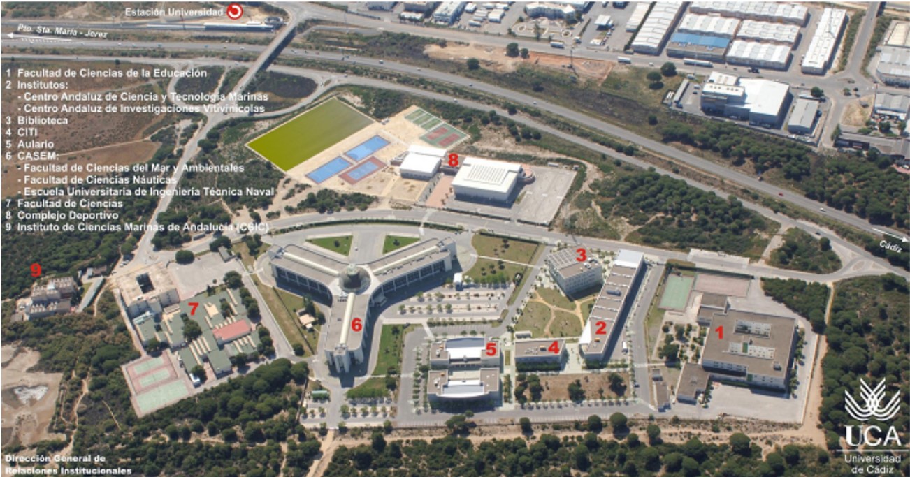
Schedule for BIP practical sessions at University of Cádiz
Important information
Monday, 28th November 2022 |
|
| 8:30am - 9:00am | Welcome session |
| 9:00am - 12:00pm |
Practical session 1
Reliable oceanographic data sources: Introduction to sea state, wind wave and wind wave climate characterization. Tomás Fernández Montblanc, Alfredo Izquierdo, Aleksandra Dudkowska |
| 12:15pm - 1:15pm |
Practical session 2
Model and satellite CMEMS Sea Surface Temperature data. Adam Gauci, Audrey Zammit, Alfredo Izquierdo |
| 1:15pm - 2:15pm | Lunch |
| 2:15pm - 4:15pm |
Practical session 2 (cont)
Model and satellite CMEMS Sea Surface Temperature data. Adam Gauci, Audrey Zammit, Alfredo Izquierdo |
| 5:00pm |
Cádiz theatrical walking tour
Meeting point: main entrance to the City Hall. Approx. duration: 90 min. |
Tuesday, 29th November 2022 |
|
| 8:30am - 11:30am |
Practical session 3
Computing satellite-derived bathymetry in shallow areas in SNAP, QGIS or ArcGIS. Adam Gauci, Audrey Zammit, Jesús Gómez-Enri |
| 11:45am - 1:15pm |
Practical session 4
Quality control and visualization data on Ocean Data View (using data from the World Ocean Database or EMODnet). Gabriela Gic-Grusza, Anna Panasiuk, Aleksandra Cupiał The materials used in this practical session have been developed by Prof. Julia Gottschalk (Institute of Geosciences, Kiel University) |
| 1:15pm - 2:15pm | Lunch |
| 2:15pm - 2:45pm | Talk show with coffee 1 |
| 2:45pm - 4:15pm |
Practical session 4 (cont)
Quality control and visualization data on Ocean Data View (using data from the World Ocean Database or EMODnet). Gabriela Gic-Grusza, Anna Panasiuk, Aleksandra Cupiał The materials used in this practical session have been developed by Prof. Julia Gottschalk (Institute of Geosciences, Kiel University) |
Wednesday, 30th November 2022 |
|
| 8:30am - 11:30am |
Practical session 5
Oil Spill Detection from space with SENTINEL-1. Jesús Gómez-Enri, Adam Gauci, Frano Matić |
| 11:45am - 1:15pm |
Practical session 6
From data formats to practical use of water column depth data. Aleksandra Cupiał, Wojciech Brodziński, Gabriela Gic-Grusza, Anna Panasiuk |
| 1:15pm - 2:15pm | Lunch |
| 2:15pm - 3:45pm |
Practical session 6 (cont)
From data formats to practical use of water column depth data. Aleksandra Cupiał, Wojciech Brodziński, Gabriela Gic-Grusza, Anna Panasiuk |
| 4:00pm |
INNOVAZUL Student Blue Space
Students have a prominent place in this edition of InnovAzul. This is the best place for them to come into contact with the business world. Information and registration at https://innovazul.es/en. Remember, for accessing INNOVAZUL you have to be registered (free of charge). Please, select as registration event STUDENT BLUE SPACE on 30th November on the registration form. |
Thursday, 1st December 2022 |
|
| 9:00am | Departure by bus from Cádiz |
| 10:00am - 12:30pm |
Cape of Trafalgar. Beach, lighthouse and tombolo of Trafalgar. Coastal and sedimentary dynamics by Tomás Fernández Montblanc. Oceanography of the Strait of Gibraltar by Alfredo Izquierdo. |
| 1:30pm - 2:30pm | Lunch (picnic) at Bolonia Beach |
| 2:30pm - 4:00pm |
Visit to
Bolonia sand dune. Meteorology of the Strait of Gibraltar by Carlos Román and Alfredo Izquierdo. Presentation of the research project "Vulnerability of littoral cultural heritage to environmental agents: the climate change impact" by Tomás Fernández Montblanc and Alfredo Izquierdo. |
| 4:00pm - 6:00pm | Visit to the Baelo-Claudia Roman city ruins and museum. |
Friday, 2nd December 2022 |
|
| 8:30am - 11:30am |
Practical session 7
Sea-level time series: detecting processes, stationarity and trends. Frano Matić, Alexandra Dudkowska, Alfredo Izquierdo |
| 11:45am - 1:15pm |
Practical session 8
Data Transformation/Integration with ETL tool - FME from SAFE. Maciej Markowski, Aleksandra Dudkowska, Wojciech Brodziński |
| 1:15pm - 2:15pm | Lunch |
| 2:15pm - 2:45pm | Talk show with coffee 2 |
| 2:45pm - 4:15pm |
Practical session 8 (cont)
Data Transformation/Integration with ETL tool - FME from SAFE. Maciej Markowski, Aleksandra Dudkowska, Wojciech Brodziński |
| 4:15pm | Closure and farewell |
Schedule for the introductory lectures
| Lecture 1 | Monday 24th October 2022 | 5:00pm-6:30pm (CEST) |
| Lecture 2 | Wednesday 26th October 2022 | 5:00pm-6:00pm (CEST) |
| Lecture 3 | Friday 28th October 2022 | 5:00pm-6:30pm (CEST) |
| Lecture 4 | Friday 4th November 2022 | 5:00pm-6:30pm (CET) |
| Lecture 5 | Monday 7th November 2022 | 5:00pm-6:30pm (CET) |
| Lecture 6 | Wednesday 9th November 2022 | 5:00pm-6:30pm (CET) |
| Lecture 7 | Monday 14th November 2022 | 5:00pm-6:30pm (CET) |
| Lecture 8 | Friday 18th November 2022 | 5:00pm-6:00pm (CET) |
| Lecture 9 | Monday 21st November 2022 | 5:00pm-6:30pm (CET) |
| Lecture 10 | Wednesday 23rd November 2022 | 5:00pm-7:00pm (CET) |
Project Mode Final Session
Thursday, 5th May 2022 at 5:00pm CESTJoin event
-->
INTRODUCTORY LECTURES PROGRAMME
| Session | University | Title | Duration | Key points of the lecture | Resources |
|
Lecture 1 24th October 2022 |
University of Malta Aldo Drago |
Introduction to Marine Data | 1.5 hrs |
|
|
|
Lecture 2 26th October 2022 |
University of Cadiz Tomás Fernández Montblanc |
Reliable oceanographic data sources: Met-ocean data sets: climate, reanalysis, forecast and in situ data | 1 hr |
|
|
|
Lecture 3 28th October 2022 |
University of Malta Adam Gauci |
Online Data Portals | 1.5 hrs |
|
|
|
Lecture 4 4th November 2022 |
University of Algarve Flávio Martins |
Introduction to Operational Modelling | 1.5 hrs |
|
|
|
Lecture 5 7th November 2022 |
IODE Peter Pissierssens *** EMODnet Jan-Bart Calewaert |
International Oceanographic Data and Information Exchange (IODE) *** An introduction to Europe’s in situ open data service by the European Marine Observation Data Network (EMODnet) |
1.5 hrs |
|
|
|
Lecture 6 9th November 2022 |
Université de Bretagne Occidentale Sally Close |
Accessing and transforming data | 1.5 hrs |
|
|
|
Lecture 7 14th November 2022 |
University of Cadiz Carlos Román Cascón |
Fundamentals and examples of marine data analysis | 1.5 hr |
|
|
|
Lecture 8 18th November 2022 |
University of Malta Joel Azzopardi |
Applying AI to Oceanography | 1 hr |
|
|
|
Lecture 9 21st November 2022 |
CAU Kiel Danyial Kazempour / Peer Kröger |
Managing and Processing (Big) Scientific Data | 1.5 hrs |
Managing (Big) Scientific Data
|
|
|
Lecture 10a 23rd November 2022 |
University of Split Hrvoje Kalinić |
Introduction to learning algorithms, neural networks and clustering | 1 hr |
|
|
|
Lecture 10b 23rd November 2022 |
University of Gdansk Aleksandra Dudkowska |
Applying AI to Oceanography: case studies | 1 hr | Case studies and demonstration of the different AI/ML models used in Oceanography |
PROGRAMME FOR REMOTE PRACTICAL SESSIONS
| Session | University | Title | Duration | Highlights on Practical | Resources | ||||||||
|
Practical Intro 20th February 2023 |
University of Malta Adam Gauci |
Introduction to practical sessions | 30 min | House keeping rules to ensure smooth running of practical sessions | |||||||||
|
Practical 1 20th February 2023 |
University of Malta Adam Gauci & Audrey Zammit |
Model and satellite CMEMS sea surface temperature data | 3 hrs |
The Copernicus Marine Environment Monitoring Service
(CMEMS) is an EU information service based on satellite
earth observation and in-situ data. CMEMS provides
state-of-the-art analyses and forecasts of oceanographic
parameters which offer an unprecedented capability to
observe, understand, and anticipate marine environment
events. CMEMS offers unique access to oceanographic
products through an online catalogue. In this project
the students will be shown how to:
|
|||||||||
|
Practical 2 23rd February 2023 |
University of Split Frano Matić & Jadranka Šepić |
Sea-level time series: detecting processes, stationarity and trends | 3 hrs |
Students will learn how to detect stationarity and trends in
oceanographic time series. The analysis will be focused on
sea-level time series.
|
|||||||||
|
Practical 3 27th February 2023 |
Université de Bretagne Occidentale Sally Close |
From in situ observations to gridded data | 3 hrs |
Practical session to enable students manipulate in
situ observations and transform the input data into
a gridded product. Through this practical, they will
also discover how data availability affects the
accuracy of the gridded output, and see how this
problem can: (1) particularly affect certain undersampled
regions of the ocean, and (2) limit the time scales
that can reasonably be resolved.
Argo data will be used as an example. The students will aim to create weekly, monthly, annual and multiannual gridded products of temperature / salinity for different regions of the ocean with varying levels of data coverage. A set of instructions will be provided so that the students can achieve their objective using a “no-programming” option: students who do not have any experience in programming can complete the practical by firstly using the Coriolis web interface to select and download the data, and then by using Ocean Data View to visualise and transform the data |
|||||||||
|
Practical 4 2nd March 2023 |
University of Gdansk Aleksandra Cupiał, Wojciech Brodziński & Gabriela Gic-Grusza |
From data formats to practical use of water column depth data | 3 hrs |
This session will include two sub-sessions.
Firstly, students will learn how to manipulate different data formats (txt, geoTiff, NCDF). During this task, emphasis will be put on the importance of selecting subsets of data (both in temporal and spatial scale) and its influence on final analysis. Secondly, students will learn the basic aspects of spatial data interpolation and discover how different methods of interpolation impact on data accuracy of the gridded output. In this part, water column depth data will be used and some aspects of the modelling of bottom topography will be emphasized. Sets of instructions will be provided so that the students can achieve the same objective using Jupyter Notebook / Python programming. |
|||||||||
|
Practical 5 6th March 2023 |
|
||||||||||||
|
Practical 6 9th March 2023 |
University of Cadiz Jesús Gómez-Enri |
Oil Spill Detection from space with SENTINEL-1 | 3 hrs | Major oil spills from sinking super-tankers, or other marine accidents like the Deepwater Horizon (DWH) oil rig explosion and collapse, are thankfully very rare these days. However, smaller oil spills from shipping are unfortunately still common. Most ships have some type of fuel on board and if they are involved in an accident, there is a risk of that fuel leaking into the sea. More worryingly, some ships still deliberately release oil into the sea. In some areas even reaching the oil can be as hard as cleaning it up. Mud flats, swamps, marsh-lands and deltas can be particularly difficult. | |||||||||
|
Practical 7 13th March 2023 |
University of Split Žarko Kovač |
Primary production time series analysis and model parameter estimation | 3 hrs |
|
|||||||||
|
Practical 8 16th March 2023 |
University of Algarve Flávio Martins |
Introduction to ocean modelling using MOHID and Bentley's Open Flows FLOOD | 3 hrs |
This module will introduce the basics of implementing and running a numerical
hydrodynamic model in a coastal zone. For that purpose the open source MOHID
water modelling system will be used, connected to the Graphical User Interface
provided by BENTLEY Systems®. Basic skills acquired in this module include:
|
|||||||||
|
Practical 9 20th March 2023 |
University of Gdansk Maciej Markowski |
Data Transformation/Integration with ETL tool - FME from SAFE. | 3 hrs |
This practical session will allow students to understand the following topics:
|
|||||||||