| Assessing the present situation – MAMA conducted an extensive survey to gather information at country level on the human, scientific, technical and infra-structural resources relevant to operational oceanography. This included the collection of meta-data on current routine activities in ocean/coastal monitoring and on observing platforms. |
| |
| Country Profiles in each Mediterranean country give an overview on: (i) the activities of entities in charge of research and operations for ocean observations and forecasting; (ii) the national structure for managing marine affairs and funding for ocean monitoring and marine research & technological development; (iii) the relevance of the marine sector to national economies. |
| |
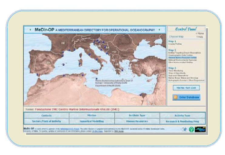
| The Mediterranean Directory on Operational Oceanography – MeDir-OP is a web-based directory of key Mediterranean entities dealing with research in support of operational oceanography, and with the monitoring of the marine environment. It includes information on potential users of marine data, on key public administrations responsible for marine affairs, on routine marine monitoring activities with details on observing platforms, and on the relevance of the marine sector for the economy of Mediterranean countries.
The information is presented in the form of maps and a user-friendly graphical interface that allows easy viewing and searching of the metadata.
MeDir-OP can be accessed online at: http://www.capemalta.net/mama/wp1interface/index.html |
 |
| |
| National Awareness Meetings -- The MAMA awareness campaign addressed the national communities of knowledge providers, potential end-users and policy makers. National Awareness Meetings were organised in each country with ample participation of stakeholders. The objective of informing on the benefits of ocean observations and obtaining consensus has been fully achieved. |
| |
| The MAMA WWW -- The MAMA website has provided a community portal to partners and information on MAMA and related activities in all countries. It served as a dissemination, awareness and visibility tool for the MAMA network and participating institutions. |
| |
| Capacity building activities – The expertise within the network has been improved through trai
ning-on-the-job opportunities. Many short and medium term visiting fellowships have been granted to MAMA researchers to gain experience at specialised centres. The activity has enabled the development of specific skills to participate in the establishment of the MedGOOS and closer working relations between partners. |
| |
| High-resolution circulation models were implemented in key shelf/coastal areas on the southern and eastern Mediterranean shores not yet covered by previous numerical modelling efforts. These models were developed by MAMA partner institutes in Morocco, Tunisia and Lebanon with the assistance of reference modelling institutions, ISMAR-CNR (Venice), UNIBO-CIRSA (University of Bologna) and IMC (International Marine Centre ONLUS). This effort included a high resolution finite element coastal model implementation in Mellieha Bay in Malta. |
| |
Designing the initial observing system – An extensive report on the adequacy of existing ocean observing systems in the Mediterranean at regional, coastal and national scales has been produced. This report will serve as a basis to design a scientifically proven and cost effective real time coastal data acquisition system. A specific study on the Malta coast, based on adaptive grid modelling, served as test case for a new approach to coastal observing and forecasting systems. The study serves also as a guideline and methodological approach to be adapted for similar applications elsewhere in the Mediterranean.
|
| |
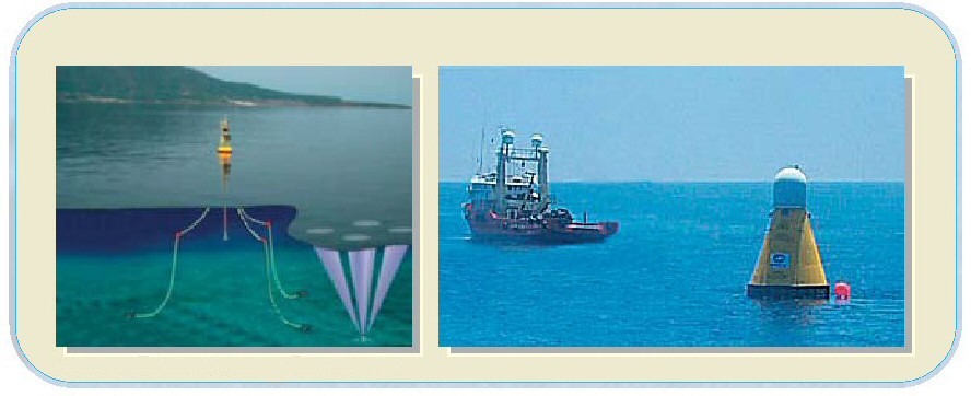
MAMA-Net - provided an online one-stop showcase of operational ocean data and information in the Mediterranean. It served as a prototype exchange system for operational data/meta-data between agencies, providing access in near real time to coastal CTD, sea level data, coastal and open sea buoys, ocean XBT, satellite ocean data, and numerical model data.
MAMA-Net can be accessed at the following address: http://vosdata.santateresa.enea.it:54321/mfs/mama/default.htm |
| |
| The Coastal Erosion Protection and ICZM Guidance Demonstrator (CEROSPIG) provides information on coastal erosion problems, and develops a capacity for an integrated Coastal Zone Management based on forecasts of the coastal environment. http://cerospig.ocean.org.il/ |
| |
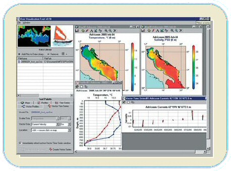
The User Visualisation Tool (UVT) is a user-friendly tool for the viewing of ocean forecasts and ecosystem model results. The UVT targets the use by the non-specialist and upholds the value addition from operational forecasts.
|
| |